
Experienced cruisers who have already covered the Caribbean and Mediterranean may want itineraries shaped as much by navigation as by the ports themselves. Narrow fjords restrict the size and movement of ships, reef passes limit access to some lagoons, and remote archipelagos leave schedules dependent on wind, tides and sea conditions.
The five routes below cross waters where local pilots, expedition teams and smaller vessels play a central role. Some replace purpose-built terminals with remote anchorages and rigid inflatable boats, while others spend several consecutive days between widely separated islands. Each route is defined by specific geography, wildlife or maritime conditions that distinguish it from a conventional port-to-port cruise. Understanding those details helps experienced passengers choose an itinerary suited to the type of sailing and shore access they want.
Sailing Past Glaciers and Fjords in Patagonia, Chile
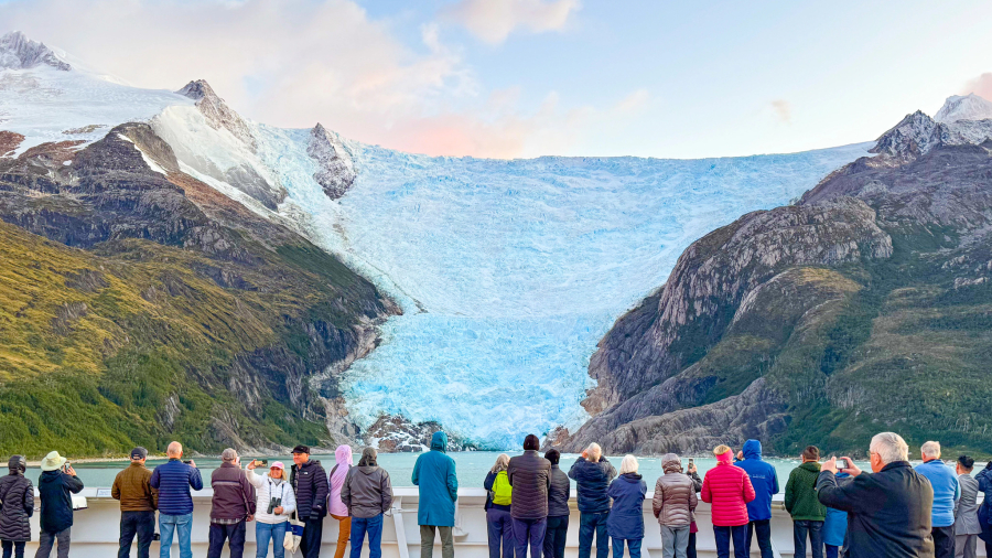
Southern Chile’s fjord routes pass through channels separating the mainland from a long chain of islands. Ships entering the Smyth Channel navigate sheltered waters bordered by steep, forested slopes before continuing toward the Strait of Magellan. Strong winds and reduced visibility can affect passage times, making the sailing itself a central part of the itinerary.
This emphasis on navigation through sheltered channels helps explain why many cruisers now choose a Patagonia cruise after completing more conventional routes. Some itineraries continue north through the Messier Channel and Eyre Fjord to Pío XI Glacier, which descends from the Southern Patagonian Ice Field. Ships approach only as closely as ice and weather conditions permit, while expedition teams may use rigid inflatable boats for nearer views where conditions allow. Passengers should bring waterproof outerwear for time on deck and expect schedules to change when wind, visibility or ice affects navigation.
Island-Hopping Whitewashed Villages in the Cyclades, Greece
Smaller-ship itineraries through the Cyclades can call at islands like Serifos and Folegandros, where port facilities are more limited than those on Santorini or Mykonos. At Serifos, Livadi sits below the island’s whitewashed Chora, which climbs steeply toward the remains of a Venetian-era castle. The elevated lanes provide views across the harbor and surrounding Aegean islands.
Folegandros has a different layout. Ships arrive or anchor near Karavostasis, while Chora stands several miles inland on the edge of a high plateau. Its compact center contains linked squares, narrow pedestrian lanes and the medieval Kastro quarter.
The summer meltemi can produce strong northerly winds and rough seas across the Cyclades, affecting tender operations and time in port. Passengers should treat landing schedules as provisional and follow updates from the bridge. When conditions permit, these calls exchange large terminals and coach transfers for smaller harbors, hillside walks and tavernas serving island cheeses and seafood.
Cruising Past Limestone Karsts in Halong Bay, Vietnam
Hạ Long Bay and the neighboring Cát Bà Archipelago contain more than 1,100 limestone islands and islets within the UNESCO World Heritage property. The landscape includes tower karsts, sea caves and enclosed marine lakes formed as seawater entered an older limestone terrain. Larger cruise ships may call at Hạ Long International Cruise Port, with local excursion vessels carrying passengers farther into the bay.
This distinctive geography helps explain why seasoned cruisers are adding a Vietnam cruise to itineraries focused on less familiar Asian waters. Excursions may include Cửa Vạn floating village, the chambers of Sửng Sốt Cave or a rowboat journey through the low entrance of Luồn Cave. Access depends on the itinerary, tides and local regulations. Mist can reduce visibility, while rain and wind may alter small-boat operations. Passengers should check whether their call includes a brief daytime circuit or an overnight sailing, as the overnight option can travel farther into the bay.
Spotting Puffins Along Rugged Cliffs in the Hebrides, Scotland
Staffa lies west of the Isle of Mull and is formed from hexagonal basalt columns created by ancient volcanic activity. Expedition ships anchor offshore, with passengers transferred by rigid inflatable boat when sea conditions permit. After landing, a narrow path above the basalt shoreline leads toward Fingal’s Cave, where waves and the columned rock create its distinctive acoustics. The route can become slippery, and access may be restricted during rough weather.
Puffins return to Staffa during the breeding season and are most readily seen in summer, alongside fulmars, guillemots and eiders. Gray seals may also be visible around rocky skerries elsewhere in the Hebrides. Wildlife sightings depend on the month and conditions, so the itinerary should match the species passengers most want to observe. Exposed anchorages and Atlantic swells can prevent landings, making a flexible schedule and additional Hebridean calls important when choosing this route.
Drifting Through Turquoise Lagoons in French Polynesia
French Polynesian itineraries cross two distinct island landscapes. In the Society Islands, volcanic peaks rise within barrier reefs, giving approaches to Moorea and Bora Bora a mountainous backdrop. Moorea’s Cook’s Bay and Opunohu Bay cut into its northern coast, while ships visiting Bora Bora anchor inside or outside the lagoon according to their size and local conditions. Passengers reach shore by tender.
The Tuamotu Archipelago consists mainly of low coral atolls surrounding broad lagoons. At Rangiroa, Tiputa and Avatoru passes connect the lagoon with the open Pacific, creating currents that determine the timing of diving and snorkeling excursions. Reef sharks, dolphins and manta rays may be encountered around these passes, although sightings aren’t guaranteed. Not every vessel can enter each lagoon, so some itineraries use an offshore anchorage and small-boat transfer. Passengers should compare port times and excursion access carefully, since a brief call may provide little time beyond the main settlement.
Which route breaks your cruise routine?
Choosing a less familiar cruise route requires different priorities. Patagonia is shaped by narrow channels, glaciers and rapidly changing weather, while the Cyclades and Hebrides place greater emphasis on small ports and landings that depend on wind and sea conditions. Hạ Long Bay requires transfers to local excursion boats, and French Polynesia may involve long distances between volcanic islands and coral atolls.
Vessel size, time in port and the method used to reach shore deserve as much attention as the destination list. Passengers should also compare the number of sea days, the likelihood of tender operations and the flexibility built into the schedule. Puffin seasons, tidal currents and ice conditions can determine what is accessible on a particular departure. For experienced cruisers, the route itself may matter more than familiar onboard amenities.